Solar Design for Challenging Terrain: Managing Slope, Soil, and Shading Risks
Challenging terrain solar design requires more than choosing efficient modules and inverters. For project managers, slopes, unstable soils, drainage constraints, and seasonal shading can affect energy yield, construction costs, permitting, and long-term asset reliability. A site that looks workable during an early walkthrough may reveal a very different risk profile after heavy rain, a winter sun study, or geotechnical investigation.
The central question is not whether difficult land can host a solar project. In many cases, it can. The real question is whether the project team can match the layout, civil works, mounting approach, construction sequence, and operating plan to the land without turning “low-cost acreage” into a high-cost asset. Good decisions made before detailed engineering often protect both the schedule and the project’s financial assumptions.
Read the terrain as a system, not a single constraint
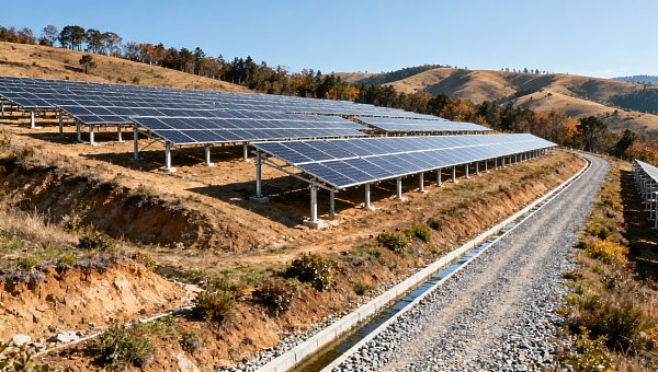
A hillside, former industrial plot, reclaimed land parcel, or irregular agricultural site rarely has only one issue. Slope affects pile installation and access roads; soil conditions influence foundation selection; drainage patterns can change after grading; nearby ridges and vegetation can create shading that is negligible in summer but material during low-sun winter months.
That is why a challenging terrain solar design process should begin with a joined-up site model rather than separate surveys completed in isolation. Topographic data, geotechnical findings, hydrology, environmental restrictions, access limitations, and solar-resource modelling all need to inform the same early layout discussion.
For a project manager, this is also a governance issue. If civil, structural, electrical, and energy-yield teams are working from different assumptions, conflicts tend to appear late—often after procurement decisions or permit submissions have already narrowed the available options.
Questions worth answering before layout optimization
- Where are the natural drainage paths during intense rainfall, not just under normal dry-season conditions?
- Which areas have slopes that make standard piling, tracker geometry, or construction access impractical?
- Are there cut-and-fill limits, protected habitats, setback requirements, or erosion-control obligations?
- Does the soil profile change across the site, particularly between ridgelines, valleys, and filled ground?
- What casts shade at the hours and seasons that matter most for annual energy production?
- Can construction equipment safely reach each block without creating excessive temporary roads or ground disturbance?
The answers may lead to a smaller but better-performing buildable area. That is not necessarily a loss. A layout that avoids costly grading, chronic washout zones, and difficult maintenance access can offer a stronger lifetime outcome than one that maximizes installed capacity on paper.
Managing slope without forcing the land into a flat-site model
Slope is often discussed as a percentage or degree, but those measurements alone do not determine suitability. What matters is how slope direction, length, variability, and terrain breaks interact with the mounting system. A consistent incline may be manageable with thoughtful row spacing and adaptable structures. A site with short, abrupt changes in elevation can be harder to develop even if its average slope appears modest.
Excessive grading is a frequent source of avoidable cost and risk. It can disturb soil structure, increase erosion exposure, create retaining requirements, and alter water movement across the property. In some locations, aggressive earthworks can also trigger additional environmental review or lengthen the approval process.
Instead of beginning with the assumption that the site must be leveled, project teams should compare several approaches: terrain-following fixed-tilt tables, segmented blocks, variable-length posts, localized grading, or a mixed mounting strategy. The right answer depends on the slope distribution and the equipment design—not on a universal maximum slope rule.
Single-axis trackers deserve particular scrutiny on irregular ground. They can improve yield under suitable conditions, but tracker rows require tight tolerances for alignment, torque-tube operation, and stow behavior. Steep or uneven terrain can increase structural complexity and installation time. In some cases, fixed-tilt systems with carefully optimized orientation provide a more predictable balance of energy, constructability, and maintenance access.
Design choices that reduce hillside risk
Break the array into topographically coherent zones rather than extending a uniform block across ridges and depressions. Align rows with drainage and erosion considerations in mind, while preserving sufficient spacing to reduce inter-row shading. Maintain practical access corridors for installation, vegetation management, cleaning where needed, and electrical maintenance. Most importantly, review the civil grading plan alongside the electrical collection design; trench routes that look efficient on a drawing can become difficult, erosive, or expensive when they cross steep ground.
Foundation design should be confirmed through field evidence. Refusal depth, rock layers, corrosive conditions, groundwater, and variable fill material can all change whether driven piles, helical piles, ground screws, ballast, or drilled foundations are appropriate. A preliminary structural concept is useful, but it should not be treated as final until geotechnical data supports it.
Soil is not merely a foundation question
When teams say a site has “poor soil,” they may mean several different things: low bearing capacity, shallow bedrock, expansive clay, loose fill, high moisture content, contamination, corrosivity, or a tendency toward erosion. Each condition creates a different design and construction response.
For example, expansive clay can move with changes in moisture, affecting foundation performance over time. Loose or heterogeneous fill may require more investigation because results from one test location may not represent the adjacent block. Highly corrosive soil may not prevent development, but it should influence material selection, coating strategy, and long-term inspection planning. On reclaimed or brownfield sites, contamination handling and worker protection requirements can change earthwork methods and project economics.
Geotechnical investigations should therefore be planned around the actual solar layout, not treated as a generic compliance step. Sampling locations need to cover representative terrain zones and suspected problem areas. The project team should also ask whether the investigation identifies seasonal conditions. A dry-site test campaign may not reveal the behavior of a low-lying section during prolonged wet weather.
From soil report to practical action
A useful geotechnical report does more than state soil classifications. It gives engineers and construction teams decision-ready information: anticipated pile depths, installation constraints, uplift and lateral-load considerations, groundwater observations, corrosion indicators, recommendations for access-road subgrades, and risks that warrant further testing.
Project managers should translate those findings into commercial controls early. If hard refusal is likely, define how pile refusal will be measured, documented, and priced. If drilling may be needed in selected zones, establish decision thresholds rather than leaving the issue to field improvisation. If soil stabilization is possible, compare its cost and schedule implications against rerouting roads or excluding marginal areas from the array.
This discipline matters because soil-related changes often ripple through the project: mounting quantities, labor productivity, equipment availability, trenching methods, drainage design, and quality-control records can all be affected. Treating soil risk as an engineering detail alone leaves procurement and scheduling teams exposed.
Drainage and erosion: the quiet threats after commissioning
Solar projects can unintentionally concentrate runoff. Module rows, access roads, cable trenches, and grading transitions may redirect water in ways that were not obvious before construction. A site can look stable at handover and then develop rills, washed-out access tracks, exposed cables, or sediment movement after its first major storm season.
Drainage planning should preserve natural flow where feasible and manage unavoidable concentration points with appropriately designed swales, culverts, check structures, riprap, vegetation, or other site-specific controls. The goal is not to move water away as quickly as possible; it is to control velocity, protect slopes, and keep runoff from undermining infrastructure or affecting neighboring land.
Construction sequencing has a major role here. Clearing a broad area before drainage controls are in place creates a vulnerable period, particularly in regions with seasonal rain. Phased construction, temporary erosion measures, and rapid stabilization of completed areas can reduce exposure. The operations team should also inherit clear inspection routes and maintenance responsibilities, because drainage systems require observation, especially after unusual weather events.
Shading analysis must look beyond the module rows
Shading is sometimes underestimated because the site appears open. Yet distant terrain, tree lines, buildings, transmission structures, and even planned landscaping can influence production. The impact is not just lost irradiance. Depending on the electrical design, partial shading can affect string behavior and increase mismatch losses.
A credible analysis evaluates horizon shading and near-field shading across the year. Winter mornings and late afternoons deserve attention because a low sun angle makes distant obstructions more significant. A vegetation survey should distinguish between removable brush, protected trees, off-site trees, and likely future growth. It is risky to assume that a neighboring landowner will maintain vegetation at a preferred height without a documented agreement.
Drone imagery, LiDAR, topographic mapping, site photography, and solar-path modelling can be combined to create a more realistic picture. The purpose is not to pursue theoretical perfection. It is to identify material constraints early enough to adjust array boundaries, row spacing, orientation, inverter zoning, or vegetation management plans.
Do not solve every shading problem with more spacing
Increasing row spacing can reduce self-shading, but it consumes land and may increase cable lengths and civil costs. On constrained terrain, a more balanced design may involve separating blocks, using different table configurations, accepting limited losses in non-critical areas, or redesigning the electrical architecture. The best option is usually the one that improves project-level value—not the one that produces the cleanest geometric layout.
A decision framework for project leaders
Before moving from feasibility to detailed design, hold a terrain-risk review with the developer, EPC team, civil engineer, geotechnical consultant, mounting supplier, energy modeller, and operations representative. The discussion should be anchored in maps and site data, not only in a capacity target.
This review is also the right moment to distinguish between risks that can be engineered away and risks that should be priced, transferred, monitored, or accepted. Not every uncertainty deserves the same response. A small area of difficult ground may justify a contingency; widespread variable fill may justify a revised site plan.
Procurement should support adaptability, not lock it out
Complex sites reward suppliers and contractors who can explain the limits of their systems clearly. During procurement, ask mounting and foundation providers for terrain envelopes, tolerances, installation prerequisites, corrosion assumptions, and examples of how they manage transitions between uneven site zones. Ask EPC bidders how they will verify subsurface conditions, control erosion during construction, and maintain access across sloped blocks.
Specifications should leave room for evidence-based adjustments while protecting performance and safety. A rigid bill of quantities can look reassuring, yet it may create disputes if site conditions differ from assumptions. Conversely, vague scope language can shift too much uncertainty into change orders. The better approach is transparent: define baseline conditions, investigation data, acceptance criteria, and procedures for handling verified exceptions.
For international sourcing teams, this is where credible technical content and supplier due diligence become valuable. Platforms such as TradeNexus Pro can help decision-makers follow green-energy supply-chain developments, compare relevant solution categories, and frame stronger questions before engaging manufacturers or service providers. The final selection still requires project-specific engineering review, but better market intelligence reduces the chance of evaluating options only on headline price.
Build for the next twenty years, not the first commissioning date
Challenging terrain solar design is ultimately an asset-management discipline. The project must remain inspectable, repairable, and safe after repeated weather cycles. Roads need to support maintenance vehicles. Drainage features need access for clearing. Vegetation plans need realistic ownership and budget. Monitoring systems should help operators distinguish between expected terrain-related variation and faults that require intervention.
Projects on difficult ground can become durable, productive infrastructure when the land is respected rather than oversimplified. Early investigation, flexible engineering, practical construction planning, and honest energy modelling create the conditions for that outcome. For project leaders, the most valuable result is not simply a site that can be built—it is a solar asset whose performance assumptions still hold when the rain arrives, the seasons change, and the operations team takes over.
Get weekly intelligence in your inbox.
No noise. No sponsored content. Pure intelligence.
 Oct 24, 2026Tesla Q3 2026 Storage Deployments Rank Second Highest as Revenue Falls 16%Tesla Q3 2026 Storage Deployments Rank Second Highest as Revenue Falls 16%
 Oct 24, 2026Freight Forwarding Services Pricing: Comparing Quotes Beyond Base RatesFreight Forwarding Services Pricing: Comparing Quotes Beyond Base Rates
 Oct 23, 2026IndexBox Issues Off-Grid Solar Outlook to 2035, Forecasting 8.2% CAGRIndexBox Issues Off-Grid Solar Outlook to 2035, Forecasting 8.2% CAGR
 Oct 23, 2026NSF/ANSI 49 Biosafety Cabinets: Product Certification vs. Field TestingNSF/ANSI 49 Biosafety Cabinets: Product Certification vs. Field Testing
 Oct 22, 2026Mitsubishi Electric Develops Industry-First Humanoid Robot–CNC Machining SystemMitsubishi Electric Develops Industry-First Humanoid Robot–CNC Machining System
 Oct 22, 2026Aerospace Aluminum Machining: How to Control Distortion in Thin-Wall PartsAerospace Aluminum Machining: How to Control Distortion in Thin-Wall Parts
 Oct 21, 2026Genesis Energy commissions 200 MWh battery storage system at HuntlyGenesis Energy commissions 200 MWh battery storage system at Huntly
 Oct 21, 2026Buying AMI Smart Meters Wholesale: Compatibility Checks and Total CostsBuying AMI Smart Meters Wholesale: Compatibility Checks and Total Costs
 Oct 20, 2026Werner Enterprises Issues Q3 Earnings Warning as Costs RiseWerner Enterprises Issues Q3 Earnings Warning as Costs Rise
 Oct 20, 2026Are Digital Twins Viable for SMEs? Costs, Use Cases, and Data RequirementsAre Digital Twins Viable for SMEs? Costs, Use Cases, and Data Requirements
 Oct 19, 2026Choosing a Wholesale Servo Motor Exporter: Traceability and Warranty ChecksChoosing a Wholesale Servo Motor Exporter: Traceability and Warranty Checks
 Oct 18, 2026Syringe Manufacturing Equipment: Evaluating Throughput and Assembly AccuracySyringe Manufacturing Equipment: Evaluating Throughput and Assembly Accuracy
 Oct 17, 2026Air Freight Forwarding Services: How to Compare Quotes for Urgent ShipmentsAir Freight Forwarding Services: How to Compare Quotes for Urgent Shipments
 Oct 16, 2026Wholesale Solar Panels: How to Compare Bulk Quotes by Total Landed CostWholesale Solar Panels: How to Compare Bulk Quotes by Total Landed Cost
 Oct 15, 2026Supply Chain Intelligence for Sourcing: How to Vet New SuppliersSupply Chain Intelligence for Sourcing: How to Vet New Suppliers
 Oct 14, 2026How energy costs shape smart manufacturing investment in EuropeHow energy costs shape smart manufacturing investment in Europe
 Oct 14, 2026How skills shortages slow smart manufacturing in Southeast AsiaHow skills shortages slow smart manufacturing in Southeast Asia
 Oct 14, 2026How CNC wire-cut machining maintains tight tolerances in thick partsHow CNC wire-cut machining maintains tight tolerances in thick parts
 Oct 14, 2026Can automated feeding stabilize metal forming in smart factories?Can automated feeding stabilize metal forming in smart factories?
 Oct 14, 2026Can CT inspection detect internal defects in metal additive parts?Can CT inspection detect internal defects in metal additive parts?
 Oct 14, 2026When does additive manufacturing reduce lead time for spare parts?When does additive manufacturing reduce lead time for spare parts?
 Oct 14, 2026How production volume affects ROI on an automated painting lineHow production volume affects ROI on an automated painting line
 Oct 14, 2026What data does manufacturing bottleneck analysis consulting need?What data does manufacturing bottleneck analysis consulting need?
 Oct 14, 2026When should you hire a consultant for manufacturing bottlenecks?When should you hire a consultant for manufacturing bottlenecks?
 Oct 14, 2026What Are Electronics Exporters' Top Supply Chain Resilience Gaps in 2026?What Are Electronics Exporters' Top Supply Chain Resilience Gaps in 2026?
 Oct 14, 2026How Do You Measure AI Adoption Maturity in a Traditional Factory?How Do You Measure AI Adoption Maturity in a Traditional Factory?
 Oct 14, 2026Are Chinese AI-Assisted Surgical Devices Gaining Global Trust?Are Chinese AI-Assisted Surgical Devices Gaining Global Trust?